59 All Posters
CATEGORY
PRICE
SIZE
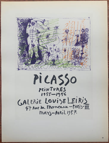
Picasso Galerie Louise Leiris #84 Product Link
Lithograph, 1959
12 x 9 in (30 x 23 cm)
$70
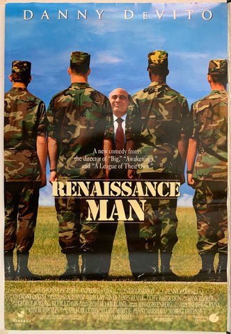
Renaissance Man Product Link
USA, 1994
41 x 27 in (104 x 69 cm)
$40
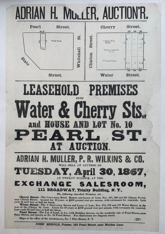
Leasehold Premises on Water & Cherry Sts. and House and Lot No. 10 Pearl St. at Auction ✓ Product Link
USA, 1867
21 x 14 in (53 x 36 cm)
$200

Fly DNL Travel Poster ✓ Product Link
Norwegia, C. 1955
40 x 25 in (102 x 64 cm)
$550

Better a live cluck than a dead cluck. Product Link
USA, C. 1944
22 x 14 in (56 x 36 cm)
$350
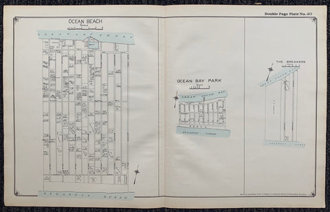
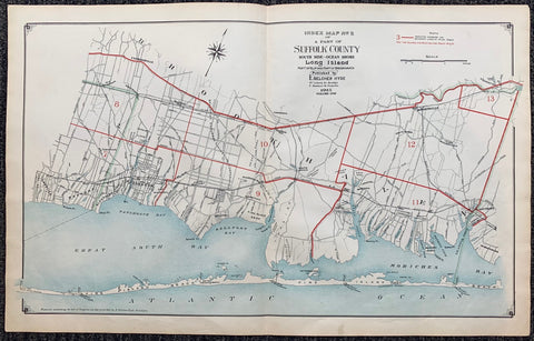
Long Island Index Map No.2 - Plate 40 Ocean Bay Park Product Link
Long Island, C. 1915
17 x 27 in (43 x 68 cm)
$200
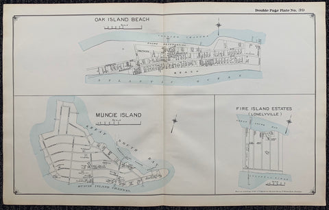
Long Island Index Map No.2 - Plate 39 Oak Island Beach Muncie Island Fire Island Estates (Lonelyville) Product Link
Long Island, C. 1915
17 x 27 in (43 x 68 cm)
$200
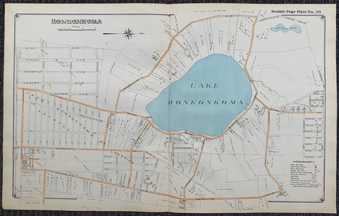
Long Island Index Map No.2 - Plate 38 Lake Ronkonkoma Product Link
Long Island, C. 1915
17 x 27 in (43 x 68 cm)
$200
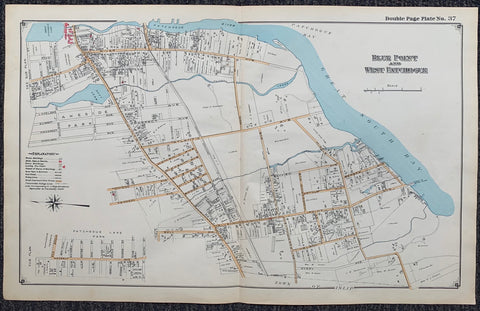
Long Island Index Map No.2 - Plate 37 Blue Point West Patchogue Product Link
Long Island, C. 1915
17 x 27 in (43 x 68 cm)
$200
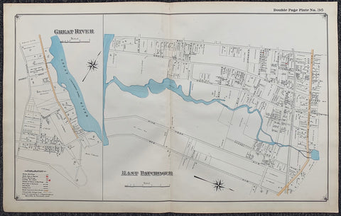
Long Island Index Map No.2 - Plate 36 Great River East Patchogue Product Link
Long Island, C. 1915
17 x 27 in (43 x 68 cm)
$200
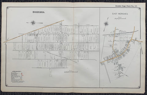
Long Island Index Map No.2 - Plate 35 East Moriches Product Link
Long Island, C. 1915
17 x 27 in (43 x 68 cm)
$200
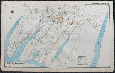
Long Island Index Map No.2 - Plate 34 Centre Moriches Product Link
Long Island, C. 1915
17 x 27 in (43 x 68 cm)
$200
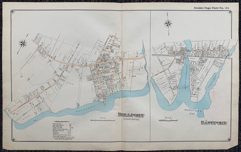
Long Island Index Map No.2 - Plate 33 Bellport Product Link
Long Island, C. 1915
17 x 27 in (43 x 68 cm)
$200
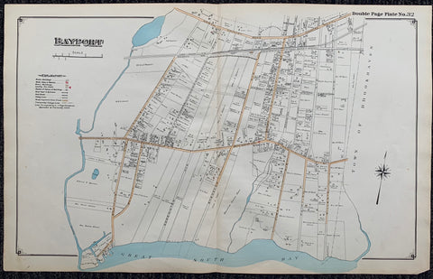
Long Island Index Map No.2 - Plate 32 Bayport Product Link
Long Island, C. 1915
17 x 27 in (43 x 68 cm)
$200
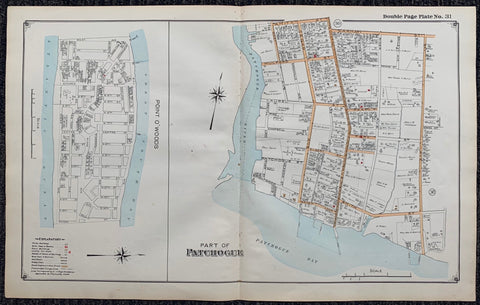
Long Island Index Map No.2 - Plate 31 Patchogue Point O'Woods Product Link
Long Island, C. 1915
17 x 27 in (43 x 68 cm)
$200
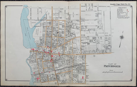
Long Island Index Map No.2 - Plate 30 Patchogue Map Product Link
Long Island, C. 1915
17 x 27 in (43 x 68 cm)
$200
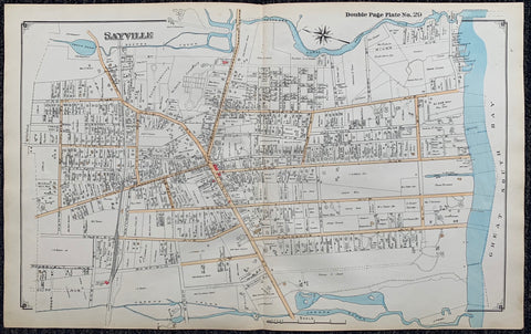
Long Island Index Map No.2 - Plate 29 Sayville Map Product Link
Long Island, C. 1915
17 x 27 in (43 x 68 cm)
$200
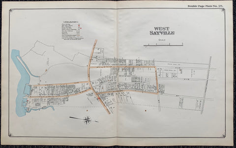
Long Island Index Map No.2 - Plate 28 West Sayville Map Product Link
Long Island, C. 1915
17 x 27 in (43 x 68 cm)
$200
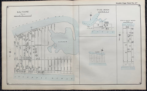
Long Island Index Map No.2 - Plate 27 Saltaire Gilgo Beach Stay a While Beach Map Product Link
Long Island, C. 1915
17 x 27 in (43 x 68 cm)
$200
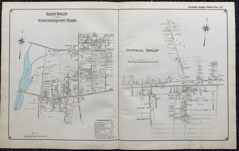
Long Island Index Map No.2 - Plate 25 Map. East Islip Connetquot Park Product Link
Long Island, C. 1915
17 x 27 in (43 x 68 cm)
$200
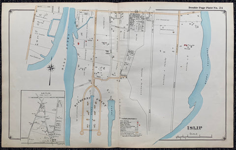
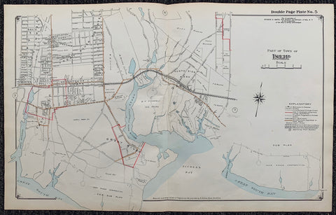
Long Island Index Map No.2 - Plate 24 Islip Product Link
Long Island, C. 1915
17 x 27 in (43 x 68 cm)
$200
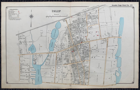
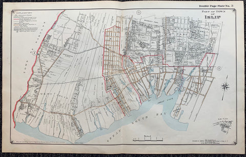
Long Island Index Map No.2 - Plate 23 Islip Product Link
Long Island, C. 1915
17 x 27 in (43 x 68 cm)
$200
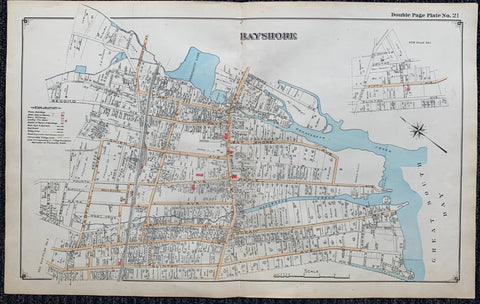
Long Island Index Map No.2 - Plate 21 Bayshore Product Link
Long Island, C. 1915
17 x 27 in (43 x 68 cm)
$200
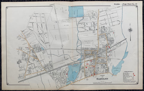
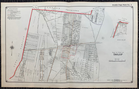
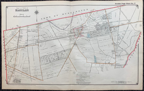
Long Island Index Map No.2 - Plate 19 Babylon Product Link
Long Island, C. 1915
17 x 27 in (43 x 68 cm)
$200
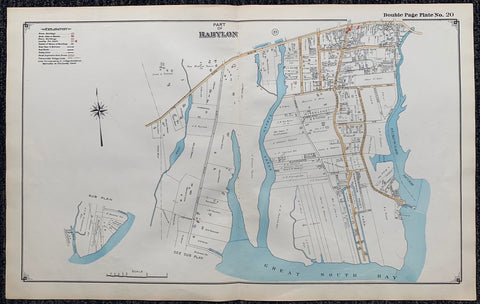
Long Island Index Map No.2 - Plate 20 Babylon Product Link
Long Island, C. 1915
17 x 27 in (43 x 68 cm)
$200
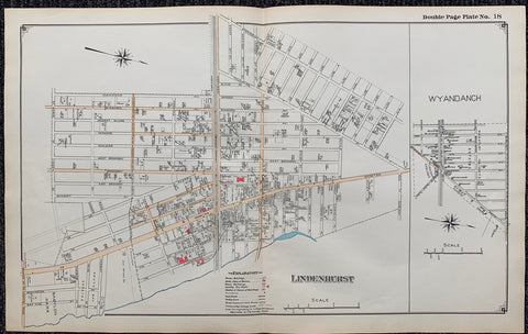
Long Island Index Map No.2 - Plate 18 Lindenhurst Product Link
Long Island, C. 1915
17 x 27 in (43 x 68 cm)
$200
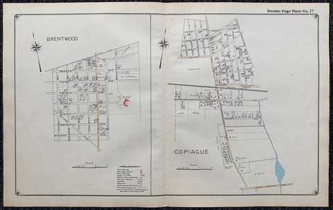
Long Island Index Map No.2 - Plate 17 BrentWood,Copiague Product Link
Long Island, C. 1915
17 x 27 in (43 x 68 cm)
$200
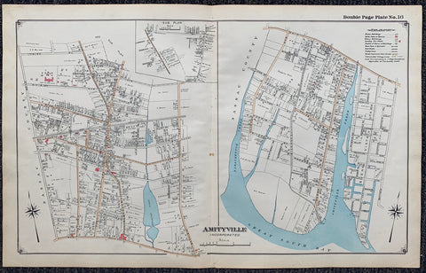
Long Island Index Map No.2 - Plate 16 Amityville Product Link
Long Island, C. 1915
17 x 27 in (43 x 68 cm)
$200
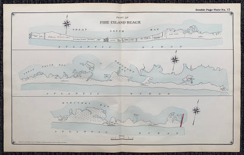
Long Island Index Map No.2 - Plate 15 Fire Island Beach Product Link
Long Island, C. 1915
17 x 27 in (43 x 68 cm)
$200
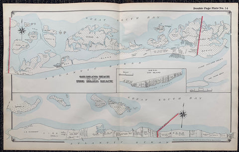
Long Island Index Map No.2 - Plate 14 Oak Island Beach, Fire Island Beach Product Link
Long Island, C. 1915
17 x 27 in (43 x 68 cm)
$200
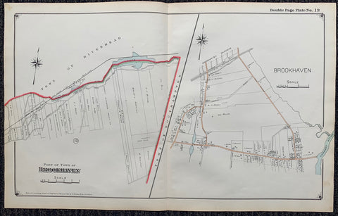
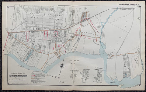
Long Island Index Map No.2 - Plate 13 Brookhaven, Southampton Product Link
Long Island, C. 1915
17 x 27 in (43 x 68 cm)
$200
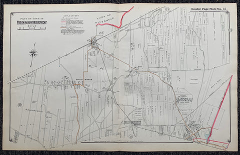
Long Island Index Map No.2 - Plate 12 Brookhaven Product Link
Long Island, C. 1915
17 x 27 in (43 x 68 cm)
$200
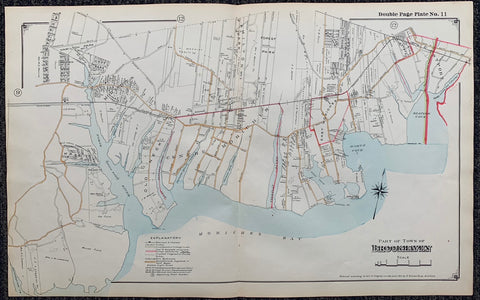
Long Island Index Map No.2 - Plate 11 Brookhaven Product Link
Long Island, C. 1915
17 x 27 in (43 x 68 cm)
$200
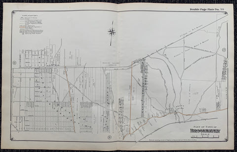
Long Island Index Map No.2 - Plate 10 Brookhaven Product Link
Long Island, C. 1915
17 x 27 in (43 x 68 cm)
$200
Long Island Index Map No.2 - Plate 9 Brookhaven Product Link
Long Island, C. 1915
17 x 27 in (43 x 68 cm)
$200
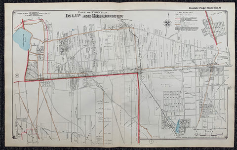
Long Island Index Map No.2 - Plate 8 Islip, Brookhaven Product Link
Long Island, C. 1915
17 x 27 in (43 x 68 cm)
$200
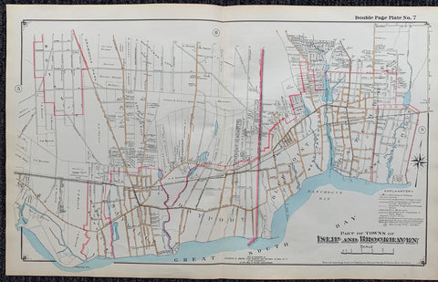
Long Island Index Map No.2 - Plate 7 Islip, Brookhaven Product Link
Long Island, C. 1915
17 x 27 in (43 x 68 cm)
$200
Long Island Index Map No.2 - Plate 6 Islip Product Link
Long Island, C. 1915
17 x 27 in (43 x 68 cm)
$200
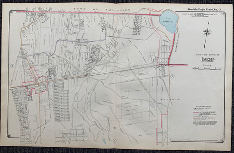
Long Island Index Map No.2 - Plate 5 Islip Product Link
Long Island, C. 1915
17 x 27 in (43 x 68 cm)
$200
Long Island Index Map No.2 - Plate 4 Islip Product Link
Long Island, C. 1915
17 x 27 in (43 x 68 cm)
$200
Long Island Index Map No.2 - Plate 3 Islip Product Link
Long Island, C. 1915
17 x 27 in (43 x 68 cm)
$200
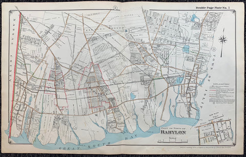
Long Island Index Map No.2 - Plate 1 Babylon Product Link
Long Island, C. 1915
17 x 27 in (43 x 68 cm)
$200
Long Island Index Map No.2 - Plate 2 Babylon Product Link
Long Island, C. 1915
17 x 27 in (43 x 68 cm)
$200
Long Island Index Map No.2 - Cover Suffolk County, Brookhaven Product Link
Long Island, C. 191515
17 x 27 in (43 x 68 cm)
$200

La Capra Product Link
Italy, 1982
39 x 55 in (99 x 140 cm)
$200

Aus Der Mechanischen Stadt Product Link
Switzerland, 1965
36 x 50 in (91 x 127 cm)
$800
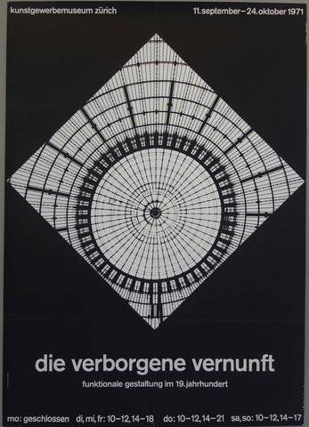
Die Verborgene Vernunft Product Link
Switzerland, 1971
36 x 50 in (91 x 127 cm)
$800
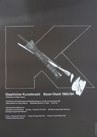
Staatlicher Kunstkredit Product Link
Switzerland, 1984
36 x 50 in (91 x 127 cm)
$450

Fibre Espace Product Link
Switzerland, 1983
36 x 50 in (91 x 127 cm)
$400

Reflection of a Heart Product Link
2008

